


Browse Topics
- Arts
- Buildings, Architecture & Monuments
- Business, Trade, Industry & Commerce
- Advertising
- Agriculture & Countryside
- Banks, Finance and Legal Services
- Domestic Service
- Innovation & Inventions
- International Contact & Trade
- Legal Services
- Printing and Publishing
- Shops & Retail
- Tourism and Hospitality
- Trades, Industries & Manufacturing
- Brass Trade
- Button Trade
- Carpet Making
- Ceramics and Pottery Industry
- Charcoal
- Chemical Industry
- Coins and Minting
- Engineering
- Glass Trade
- Gun, Sword and Weapons Trade
- Iron and Metal Trades
- Jewellery, Decorative and Toy Trades
- Mining
- Needle and Fish Hook Trades
- Pewter Industry
- Rope Industry
- Textile Industry
- Tools, Machinery and Equipment
- Unemployment
- Work, Pay & Conditions
- Culture & Diversity
- Events, Celebrations & Disasters
- Health & Medicine
- Religion, Ideas & Beliefs
- Science, Nature and Environment
- Society
- Sport & Leisure
- Transport
Geography
A Sorry End: The Priestley Riots of 1791
Image: Ticket for the French Revolution Dinner, Birmingham 14 July 1791. The Dinner began the chain of events… read more »
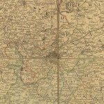
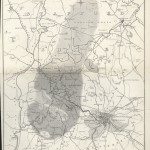
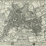
Birmingham and the Country Around, 1798
Image: ‘A MAP OF UPWARDS OF 25 MILES ROUND THE TOWN OF BIRMINGHAM. To his most sacred MAJESTY… read more »
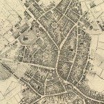
Birmingham in 1751
Image: This is a street plan from 1751, surveyed by Samuel Bradford and engraved by Thomas Jefferys. Samuel… read more »
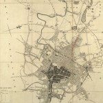
Birmingham in 1810
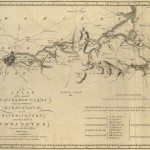
TO THE COMMISSONERS OF THE STREET ACTS, THIS MAP OF THE TOWN AND PARISH OF Birmingham, Showing… read more »
Canal Maps
Image: ‘PLAN of the intended NAVIGABLE CANAL from the TOWN of BIRMINGHAM into the RIVER SEVERN near the… read more »
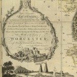
Cartouches
Image: Cartouche from 1772 map of Worcestershire. Fruit is important to the agriculture of Worcestershire, and fruit of… read more »
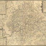
Early Warwickshire Maps
Image: The ‘Anonymous’ map of Warwickshire Printed by John Overton of London. The date on it is… read more »
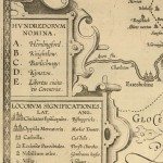
Keys and Explanations
Image: One of the earliest keys, from the late seventeenth century copy of the 1603 ‘Anonymous’ map. This… read more »
Keys and Explanations
Image: Key from map of Staffordshire, Phillips & Hutchings, 1832. Image from: Local Studies and History, Birmingham Central Library… read more »
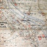
Map of the Mining and Manufacturing District of South Staffordshire, Warwickshire, etc.
William Hawkes Smith, Birmingham and its Vicinity as a Manufacturing and Commercial District (London and Birmingham, 1836).… read more »
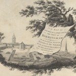
Maps and Map Making: the West Midlands Experience
Image: Cartouche from James Sherriff’s map of the area for 25 miles around Birmingham, 1798. Image from:… read more »
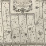
The First Road Maps, John Ogilby, 1697
Image:The road-map showing part of the route between London and Welshpool, from John Ogilby’s Britannia, published in… read more »
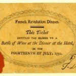
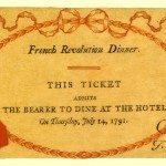
The French Revolution Dinner 14 July 1791
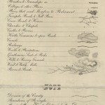
Image: French Revolution Dinner. This Ticket entitles the bearer to a Bottle of Wine at the Dinner at… read more »
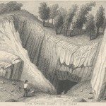
The Lime Strata Near Dudley: The Wren’s Nest, Dip East
William Hawkes Smith, Birmingham and its Vicinity as a Manufacturing and Commercial District (London and Birmingham, 1836).
Tithe Maps
Image: Tithe Map of Smethwick Image from: Birmingham City Archives Tithe maps mark the end of an era. From… read more »
William Westley’s Plan of Birmingham, 1731
Image: The 1731 town plan of Birmingham bears this dedication: To the Honourable Edwd. Digby & Willm. Peyton… read more »